|
|
|
Some of the better maps made previously have been kept, but much of the old work has been scrapped or succumbed to lack of space when the server could no longer be retained. For this reason also, no map files are now readily available for downloading, but the ones listed below can be obtained by contacting the maker directly and ordering a copy either by email or on CD.
Some of the other maps that were on this site previously may be revamped and made available again. Look in again or get in touch for further information.
Maps Currently Available
 Click for a larger view |
 |
 Click for a larger view |
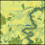
Friedland An original construction of the 1807 battlefield for NIR. Made using various sources, both topographical and verbal descriptions of the ground and the battle. The entire field fits easily into 80x70 hexes. |
||
|
||
 Click for a larger view |
 |
 Click for a larger view |
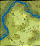
Bukrin A map 76 hexes square, with a different appearance to the usual, being made to represent late autumn or winter, with brown and bare trees, muddy, empty fields and a generally colder, more bleak feel. |
||
|
||
|
 |
|
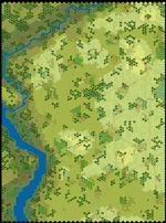
Warka Set in Poland and fitting for the 1807 campaign or later, this map also has a section of major river as its northern boundary. The remainder is rolling hills broken up by small woods, gullies, streams and villages. At 72x84 hexes it is big enough to pick many good positions on. |
||
|
||
 Click for a larger view |
 |
 Click for a larger view |
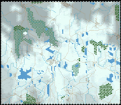
Eylau Greg Gorsuch's innovative map for the famous winter battle showed some anomalies on closer inspection. Some of the streams were running over hills, particularly in the SW corner (see map fragment, right, for corrections). There were also some bridges missing, differences between 2D, 3D and the .map files, and some lakes with hills in the middle. |
||
|
||
|
 |
 Click for a larger view |
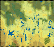
Eylau in summer The same map as the original Eylau but in warmer weather. The map section view in the right is the same area as that of the winter map above, for comparison. |
||
|
||
|
||